Introduction
I went to State of the Map US this past weekend in Richmond, VA and learned more about Protomaps which makes self-serving your own static map tiles dead simple. This is the area of the web mapping ecosystem I am furthest away from, so I often rely on 3rd party vendors (as do most), such as Mapbox or Maptiler. Protomaps makes it possible to control this component and generate tiles from a PBF I own/manipulated and serve it all from, for example, the same Github page that I might be hosting my simple site under.
The Protomaps website contains sufficient document, I will just make some notes about gotchas that I hit when working on this to get up and running under my personal website kuanbutts.com. The reference repository for this work is on Github here.
Generate PMTiles
Protomaps uses a vector tile format called PMTiles. It has nifty features that allows the API to use HTTP range requests to query a single file containg the compressed basemap information.
Simple PMTiles for a custom area can be generated with this offered PMTiles service from Protomaps. Working with a Shapefile or some other custom data source? PM allows for export from Tippecanoe to PMTiles.
For me, I downloaded a bounding box around Oakland from the simple PM service and the resulting file was about 15mb. PM will extend the map rendering functionality to support HTTP range requests thereby enabling a direct query from the map rendering engine to the single hosted PMTile.
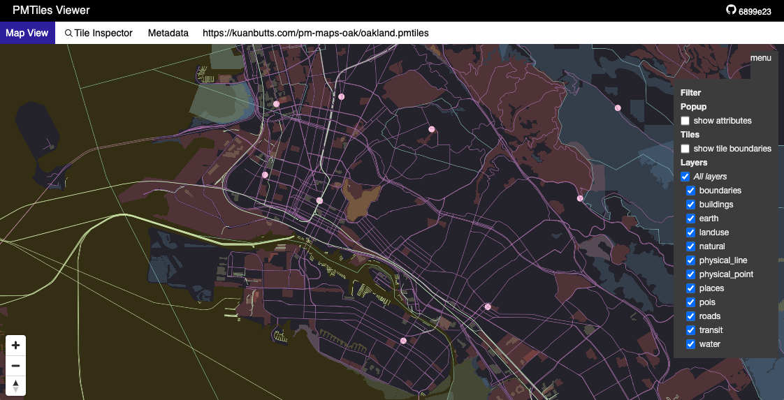
Protomaps also provides a tile inspector that will load the exported PMTiles into a viewport that will help to expose the various layer and contents that have been packaged up. If further file size efficiency is desired; this is a great tool with which to additionally trim down the pacakged OSM data to just what is needed for a specific use case.
Hosting locally for development
Once you have your PMTile file, you can start a simple SPA React app with the create-react-app command. I then chose to place the file within the public/ directory so that published builds would roll up and deliver the file to Github published static sites. You can see the file there here. This also prevents gotchas where the file is requested from the main/ branch but your personal site has a custom domain, which will cause a CORS cross-domain request headache.
Once held in a steady location, use your desired method to serve the file over local host (for ex: python -m http.server or with JS: http-server . -p 8020 --cors).
Rendering the map
Once a simple app has been created, a Map component can be introduced to the main App.js script. The entirety of the map-from-local-Github-pages-files concept will be encapsulated in that new Map component.
First, a conditional for development vs. deploy needs to be set so that when published, we can read from appropriate endpoint:
const basePmUrl = process.env.NODE_ENV === 'development' ? 'http://127.0.0.1:8080/public' : 'https://kuanbutts.com/pm-maps-oak';
Next, we will create a new instance of a MapLibre map instance. However, before we do that, there is a configuration setting that needs to be set:
import { Protocol } from 'pmtiles';
import layers from 'protomaps-themes-base';

let protocol = new Protocol();
maplibregl.addProtocol("pmtiles", protocol.tile);
This added protocol will allow Protomaps to query with the aforementioned range requests. Once set, all that is left to do is to create a new MapLibre map instance with the requisite style settings for Protomaps + MapLibre to use to query from the static file (instead of a traditional tiling service):
new maplibregl.Map({
  container: mapContainer.current,
  style: {
    version: 8,
    glyphs:'https://cdn.protomaps.com/fonts/pbf/{fontstack}/{range}.pbf',
    sources: {
      protomaps: {
            type: 'vector',
            url: `pmtiles://${basePmUrl}/oakland.pmtiles`,
            attribution: '<a href="https://protomaps.com">Protomaps</a> © <a href="https://openstreetmap.org">OpenStreetMap</a>'
        }
    },
    layers: layers('protomaps', 'light')
  },
  center: [lng, lat],
  zoom: zoom,
  maxBounds: [[-122.36159, 37.71505], [-122.12976, 37.88092]]
});
Conclusion
That’s about it. The simple web site is up on Github here. The webapp queries the PMTiles raw file, which is exposed via the public/ bucket in the final custom domain/path endpoint the same as the rest of the site JS, static files. With this pattern, I am able to publish a simple website without any external resource requirements outside what is delivered and available from the single site.